
By Kyle Coppola
8pm Update from Lake and Sumter Style Weather Center


Hurricane Ian makes landfall as a Category 4 Hurricane!
The latest from our Weather Center indicates that Hurricane Ian has made landfall along the southwestern coast of Florida near Cayo Costa. Punta Gorda has been severely impacted and so has Naples. Wind speeds as the Hurricane came to shore measured upwards to 140mph which is Category 4 strength. We have some incredible images of Hurricane Ian rom 22,000 miles away taken by a NASA GOES Spacecraft.

Downgraded to a Category 3 Storm
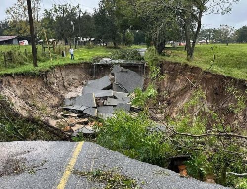
Hurricane Ian has been downgraded to a Category 3 storm but with these extremely dangerous conditions that this hurricane is unleashing upon Florida include catastrophic winds and floods we need to continue to watch its path. The storm surge in the costal regions have been absolutely terrifying to watch. Flooding and dangerous winds will continue as the storm continues inland. There are already a reported 1.5 Million people without power in Florida and that number will likely continue to rise.
The storm has now unleashed its fury and the eye is currently beginning to disorganize across the state but is still very powerful. The backside of this hurricane is going to produce some intense winds that can be very destructive. Weather Channels Jim Cantore has been covering this and the results have been incredible. Very scary storm.
Lake And Sumter Counties – When to expect Ian
Today has been relatively quiet but it will not remain that way for long. The good news for our area is that the eye has pushed so far south, that we are now out of the cone of uncertainty. 48 hours ago that was not the case but the storm is moving at a very slow speed now. It is actually creeping along and thats causing massive amounts of water to pound the coastal regions.
The rain chances continue to hold steady for our area and by the time this storm hits, it should be late at night around 2am to early Thursday morning where we will see some of the worst rains hit us. Lake and Sumter Counties are under a continued Hurricane Warning as well as a Flood watch and a Tornado Warning.
In just a few hours the worst of the hurricane will be here. We are expecting winds in excess of 45 – 75mph with the worst winds and micro bursts of up to 90mph. All indications point toward the backside of the storm belting us with rain and wind. Flash flooding could possibly occur as the storms backside unleashes upon our counties.
Take Every Precaution Now
We cannot state this enough tonight is going to be windy, rainy and likely be as very long morning for us all. We are expecting a foot to possibly two feet in some areas. The rain chances have diminished slightly but when the backside of the storm comes that will bring most of the rain along with it. We are hopeful that the continued path brings most of the storm further south but if it continues on its current track moderate to high winds will affect us this evening. Please be safe and continue to keep an eye on our coverage for the latest info in our area.

The Hurricane Eye has again shifted south by a few miles but the impacts to Lake and Sumter Counties will still potentially be very dangerous. Recent info our weather center has received from an Air Force Reserve Hurricane Hunter Aircraft indicated that the maximum sustained winds have increased to 140mph with higher gusts around 155mph. We are expecting some fluctuations in intensity before the storm reaches land due to Wind Shear. The storm is being pulled to the right and will change its path rapidly as it approaches Naples. The resulting shear will turn the storm on a direct heading for Florida. Our hope is that once on land the shear will disorganize the storm enough so that inland damage is not as bad.

Flooding
The National Weather Service has issued A Flood Watch which remains in effect for Lake and Sumter Counties until Friday at 2am. Flooding caused by excess rainfall is expected. Impacts include extensive street flooding and flooding of creeks and rivers are possible. We do have many creeks and rivers along with lakes running high already so if your are in these areas be prepared with a plan
Tornado Watch
Our area remains under a Tornado Watch. The tornado threat has remained nearly steady since the last assessment. This threat will continue until tomorrow afternoon. Please listen to local radio and download the Weather Channel app for the most up to date information. We will also be posting every few hours updating Hurricane Ian and its path.
Lake & Sumter county shelters open
Primary Shelters
- East Ridge High School – 13322 Excalibur Road, Clermont
- East Ridge Middle School – 13201 Excalibur Road, Clermont
- Eustis High School – 1300 E. Washington Ave, Eustis
- Leesburg High School – 1401 Yellow Jacket Way, Leesburg
- Mount Dora High School – 700 N. Highland St. Mount Dora
- Tavares High School – 603 N. New Hampshire Ave, Tavares
Pet Friendly Shelters
- Mascotte Elementary School – 460 Midway Ave, Mascotte
- Round Lake Elementary School – 31333 Round Lake Road, Clermont
- Spring Creek Elementary School – 44440 Spring Creek Road, Paisley
- Treadway Elementary School – 10619 Treadway School Road, Leesburg
- Astatula Elementary School – 13925 Florida Ave, Astatula
- Leesburg Elementary School – 2229 South St, Leesburg
- Lost Lake Elementary School – 1901 Johns Lake Road, Clermont
- Umatilla Elementary School – 401 Lake St, Umatilla
- Villages Elementary School – 695 Rolling Acres Road, Lady Lake
Special Needs Shelters
- Astatula Elementary School – 13925 Florida Ave, Astatula
- Leesburg Elementary School – 2229 South St, Leesburg
- Lost Lake Elementary School – 1901 Johns Lake Road, Clermont
- Umatilla Elementary School – 401 Lake St, Umatilla
- Villages Elementary School – 695 Rolling Acres Road, Lady Lake
Sandbag Locations available from 8am – 5pm daily
- Residents must bring own shovels and are limited to 10 bags
Astor Area (Fire Station #10)
- 23023 State Road 40, Astor, FL 32102
East Lake Sports and Community Complex
- 24809 Wallick Rd, Sorrento, FL 32776
P.E.A.R Park
- 26701 US Hwy 27, Leesburg, FL 34748 (Use Front Entrance)
North Lake Regional Park
- 40730 Roger Giles Rd, Umatilla, FL 32784
Minneola Athletic Complex
- 1300 Fosgate Road (13930 Education Ave) Minneola, FL
The City of Clermont – West Park Ballfields
- 658 12th Street, Clermont
The City Of Eustis – Eustis Fire Station 22
- 100 W Norton Ave, Eustis, FL 32726
If You Have Pets
- Have extra water and food on hand to last one week or more. We recommend having a plan to toilet your pets inside the house during the worst of the storm if necessary. High winds and debris will be potentially dangerous if not lethal to pets so have this plan in place.
- Have a plan in case a pet is injured. There are local urgent care centers in the area which you should inform yourself on.
- Hand powered can opener – In case the power is out for a prolonged period many pet foods are opened by an electronic can opener. Make sure to have a manual one on hand just in case.
- Toys and Treats – To reduce stress make sure to have toys and treats on hand.
- Medical Records – Make sure to have medical records on hand in case, including photos of your pets.
- Microchip – A good rule of thumb is to always have your pets microchipped in order to find them if they get lost.

Kyle Coppola was born in Newton, Massachusetts and received his Bachelor of Fine Arts in Communications from Curry College in 2016. After traveling to Florida on a family vacation, he decided he could not get enough of the warm weather and made the move from snowy Massachusetts to central Florida 8 years ago.
For the last decade Kyle has gained valuable experience in social media content creation, marketing and sales, writing, video production, sports announcing and even broadcasting for local radio stations, such as FM 102.9 in The Villages and FM 91.5 in Massachusetts. Every year he volunteers at The Villages Charter High School as a play-by-play sports announcer for the football games as well as a public address announcer for the basketball games, including the annual Battle at The Villages Tournament.
Outside the office Kyle is a husband and father to two beautiful girls along with their cat. In his spare time he likes to spend time with his family, travel, play golf and swim. He is also a huge sports junkie and even bigger motorsports fan and loves to attend racing events when he can.