By Kyle Coppola
4pm Update from Lake and Sumter Style Weather Center

Extremely Dangerous Ian Battering Florida’s West Coast
A hurricane of inches! As soon as Hurricane Ian reached about 40 miles off shore of mainland Florida it has suddenly halted to a crawl. Wednesday morning we were already looking at a Category 4 Hurricane. As of a 2pm Hurricane Hunter Aircraft update Ian remained at a Category 4 hurricane.
The EYE
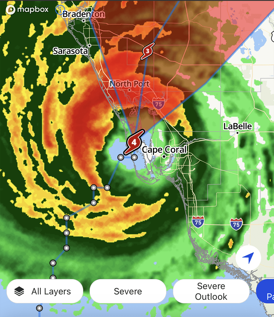
The eye is literally hanging over Cape Coral Florida Right Now. If you have friends or family down there we pray that they are safe right now. It is a very frightening scene of debris and wind pounding Cape Coral Beach. North Port Floria is likewise being belted by this storm. We can only hope that the storm picks up its pace because the rate of speed has diminished significantly.
The storm is expected to cause life-threatening damage and catastrophic wind and flooding is expected in the Florida peninsula. Right now the center of the storm is scheduled to move over Central Florida on Wednesday Night and Thursday Morning emerging over The Western Atlantic Ocean by late Thursday. The Hurricane has slowed down as it begins its turn inland. Wind Shear has deterred the hurricane from becoming a CAT 5. That is good news but the bad news is that Ian is still a Category 4 and that is still a devastating storm.
Lake And Sumter Counties
We are currently under a Hurricane Warning. What that means is that we can expect 30-50 knot winds with gusts up to 75 knots. Extremely strong winds will cause hazardous conditions. The Storm’s eye has not changed much but it is now closing in on Venice and North Port Florida and is scheduled to slam into Florida this afternoon. The exact time of Landfall remains late this afternoon and The Center of Ian is forecast to move over Central Florida Wednesday Night and Thursday Morning emerging over The Western Atlantic by late Thursday.
Rainfall Amounts
The rainfall amounts for our area have actually dissipated just slightly. Many areas are looking at around 1 foot or 1.5 feet of rainfall. Some areas may still see 2 feet in some areas. Be advised that this is an ever changing storm and the rainfall amounts can vary especially due to the Shear the storm is now undergoing. Just 48 hours ago we though this storm may end up in the panhandle and now its coming right across our bow.
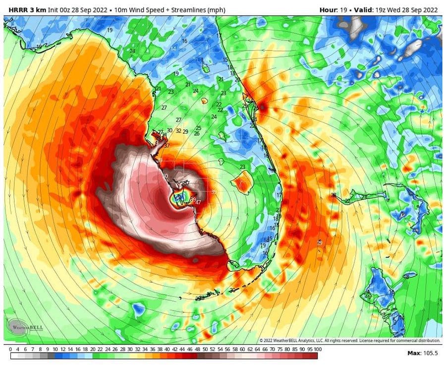
The Hurricane Eye has again shifted south by a few miles but the impacts to Lake and Sumter Counties will still potentially be very dangerous. Recent info our weather center has received from an Air Force Reserve Hurricane Hunter Aircraft indicated that the maximum sustained winds have increased to 140mph with higher gusts around 155mph. We are expecting some fluctuations in intensity before the storm reaches land due to Wind Shear. The storm is being pulled to the right and will change its path rapidly as it approaches Naples. The resulting shear will turn the storm on a direct heading for Florida. Our hope is that once on land the shear will disorganize the storm enough so that inland damage is not as bad.
Flooding
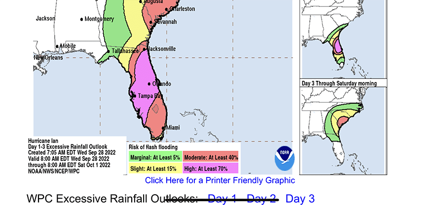
The National Weather Service has issued A Flood Watch which remains in effect for Lake and Sumter Counties until Friday at 2am. Flooding caused by excess rainfall is expected. Impacts include extensive street flooding and flooding of creeks and rivers are possible. We do have many creeks and rivers along with lakes running high already so if your are in these areas be prepared with a plan
Tornado Watch
Our area remains under a Tornado Watch. The tornado threat has remained nearly steady since the last assessment. This threat will continue until tomorrow afternoon. Please listen to local radio and download the Weather Channel app for the most up to date information. We will also be posting every few hours updating Hurricane Ian and its path.
Lake & Sumter county shelters open
Primary Shelters
- East Ridge High School – 13322 Excalibur Road, Clermont
- East Ridge Middle School – 13201 Excalibur Road, Clermont
- Eustis High School – 1300 E. Washington Ave, Eustis
- Leesburg High School – 1401 Yellow Jacket Way, Leesburg
- Mount Dora High School – 700 N. Highland St. Mount Dora
- Tavares High School – 603 N. New Hampshire Ave, Tavares
Pet Friendly Shelters
- Mascotte Elementary School – 460 Midway Ave, Mascotte
- Round Lake Elementary School – 31333 Round Lake Road, Clermont
- Spring Creek Elementary School – 44440 Spring Creek Road, Paisley
- Treadway Elementary School – 10619 Treadway School Road, Leesburg
- Astatula Elementary School – 13925 Florida Ave, Astatula
- Leesburg Elementary School – 2229 South St, Leesburg
- Lost Lake Elementary School – 1901 Johns Lake Road, Clermont
- Umatilla Elementary School – 401 Lake St, Umatilla
- Villages Elementary School – 695 Rolling Acres Road, Lady Lake
Special Needs Shelters
- Astatula Elementary School – 13925 Florida Ave, Astatula
- Leesburg Elementary School – 2229 South St, Leesburg
- Lost Lake Elementary School – 1901 Johns Lake Road, Clermont
- Umatilla Elementary School – 401 Lake St, Umatilla
- Villages Elementary School – 695 Rolling Acres Road, Lady Lake
Sandbag Locations available from 8am – 5pm daily
- Residents must bring own shovels and are limited to 10 bags
Astor Area (Fire Station #10)
- 23023 State Road 40, Astor, FL 32102
East Lake Sports and Community Complex
- 24809 Wallick Rd, Sorrento, FL 32776
P.E.A.R Park
- 26701 US Hwy 27, Leesburg, FL 34748 (Use Front Entrance)
North Lake Regional Park
- 40730 Roger Giles Rd, Umatilla, FL 32784
Minneola Athletic Complex
- 1300 Fosgate Road (13930 Education Ave) Minneola, FL
The City of Clermont – West Park Ballfields
- 658 12th Street, Clermont
The City Of Eustis – Eustis Fire Station 22
- 100 W Norton Ave, Eustis, FL 32726
If You Have Pets
- Have extra water and food on hand to last one week or more. We recommend having a plan to toilet your pets inside the house during the worst of the storm if necessary. High winds and debris will be potentially dangerous if not lethal to pets so have this plan in place.
- Have a plan in case a pet is injured. There are local urgent care centers in the area which you should inform yourself on.
- Hand powered can opener – In case the power is out for a prolonged period many pet foods are opened by an electronic can opener. Make sure to have a manual one on hand just in case.
- Toys and Treats – To reduce stress make sure to have toys and treats on hand.
- Medical Records – Make sure to have medical records on hand in case, including photos of your pets.
- Microchip – A good rule of thumb is to always have your pets microchipped in order to find them if they get lost.
Kyle Coppola was born in Newton, Massachusetts and received his Bachelor of Fine Arts in Communications from Curry College in 2016. After traveling to Florida on a family vacation, he decided he could not get enough of the warm weather and made the move from snowy Massachusetts to central Florida 8 years ago.
For the last decade Kyle has gained valuable experience in social media content creation, marketing and sales, writing, video production, sports announcing and even broadcasting for local radio stations, such as FM 102.9 in The Villages and FM 91.5 in Massachusetts. Every year he volunteers at The Villages Charter High School as a play-by-play sports announcer for the football games as well as a public address announcer for the basketball games, including the annual Battle at The Villages Tournament.
Outside the office Kyle is a husband and father to two beautiful girls along with their cat. In his spare time he likes to spend time with his family, travel, play golf and swim. He is also a huge sports junkie and even bigger motorsports fan and loves to attend racing events when he can.


